
Mapping Ararat: An Imaginary Jewish Homelands Project
Presented by Melissa Shiff (University of Toronto); Louis Kaplan (University of Toronto); John Craig Freeman (Emerson College) at “From Access to Integration”
Mapping Ararat combines historical research and artistic creation to image and imagine Mordecai Noah’s vision of establishing a Jewish refuge. This collaborative digital arts and humanities work-in-progress gives Grand Island, New York the virtual chance to become the Jewish homeland that its founder envisioned. The project also offers new approaches to coordinating and integrating different digital technologies.
First, there is the familiar website platform with a rich collection of material drawn from all of the archives where research has been conducted. Resources include maps, photographs and newspapers from the period. The website also has a social media component that allows for wide dissemination, as well as the ability to broadcast upcoming news and events, post comments and access documentation of the major artistic components of the project.
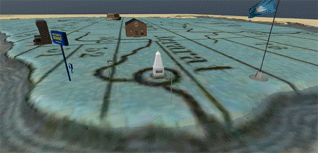
The augmented reality elements of the project include a virtual flag and an on-site walking tour of “Ararat”—a place that now exists virtually in exactly the geographical location that its creator had intended. A user must download the augmented reality browser “Layar” onto his or her smart phone to be able to view the architecture and landmarks that do not actually exist as assets in the physical landscape but are housed on a server and inserted into the landscape virtually.
With a smart phone, a user will activate location services to determine exactly where he or she is standing; according to this physical location, images of buildings and other landmarks will appear on the phone’s screen. These virtual objects are tied to particular locations, allowing a user to physically walk around and take a tour (using a phone) of a virtual landscape. As GPS technology allows a phone to pinpoint an exact location, the user will be able to see the synagogue, mikvah, graveyard, casino and Noah’s Ark theme park (to name a few elements of the project) that are now a digital part of the imagined land of Ararat. Viewers are also able to access primary source materials using this same technology, providing them with supplemental information on-site.
Another component of the project is to use a digital map in order to overlap the topography and a gaming software program known as “Unity,” where visitors can chart a course through the map using a joystick controller. Samples of vernacular culture—postcards, money, stamps, newspapers—will be juxtaposed with actual grand island artifacts or newspapers with which Mordecai Noah was associated. Video interviews with scholars will illuminate the material.
If you would like to share your digital project with us, please email us at commons@cjh.org. To tell your colleagues about Jewish Commons, click here.
Be the first to add a comment.
ÿþ<> ロイヤルコレクション ROYAL COLLECTION TRI ONE FLEX 41 トライワンフレックス41 スイング練習器 Kappa カッパ 半袖シャツ 《GOLF COLLECTION》 KG312SS43 オデッセイ ホワイト ライズ iX テロン Σ(シグマ) パター アンバランスボーダーVネックルーズニット秋の新作ニット Vネック 長袖 ボーダー ストライプ ルーズ セレブファッション 裾が揺れるエレガントなカットソーボリューミーシンプルカットソー トップス Tシャツ 無地 半袖 セレブファッション セレブ レディース ナウアイスタイル 袖をめくればレースが見えるレースプリントTシャツ Tシャツ カットソー レース プリントTシャツ セレブファッション セレブ レディース ナウアイスタイル RAIN CAPE レインケープ DANKE ダンケ DEZ-6-6 CHECK RED×BLUE レインコート·ポンチョ キッズ·女の子用ヘルメットNINA viser ニノ バイザー付 カラー:SATIN PINK CAMOBERN バーン Bucket Pack バケットパック Charcoal x PurpleSIZE: S SIZEFREDRIK PACKERSフレドリック パッカーズ ★ OLYMPUS/オリンパス OLYMPUS PEN Lite E-PL7 14-42mm EZ レンズキット(シルバー) 【送料代引き手数料無料!】 (EPL7EZLKIT) 特徴機能 どんな商品? 発売日:2014年9月下旬自分撮りに特化した機能を搭載したPEN Lite E-PL7 と世界最薄電動式パンケーキズームレンズキット ■タッチ自分撮りスタイル 快適な自分撮りを可能にするため、大型高精細のタッチパネル&下開きモニターや、自�#12459;メラバッグプレゼント!] OLYMPUS/オリンパス OLYMPUS PEN Lite E-PL7 14-42mm EZ レンズキット(シルバー)
★ OLYMPUS/オリンパス ズイコーデジタル ED 9-18mm F4.0-5.6 (ED918MMF4.05.6) 特徴機能 どんな商品? 発売日:2008/10/25超小型軽量設計を実現した超広角(35mm判換算 18-36mm)ズームレンズ、ED 9-18mm F4.0-5.6は、フォーサーズならではの優れた機動性により、超広角撮影をより身近なものにしています。35mm判換算で18-36mmの焦点距離を実現しながら、DSA(デュアルスーパー非球面)レンズの�OLYMPUS/オリンパス ズイコーデジタル ED 9-18mm F4.0-5.6
★ CANON/キヤノン PowerShotSX280セット PowerShot SX280 HSと液晶保護フィルムセット (PowerShotSX280s) 特徴機能 どんな商品? キヤノン PowerShot SX280 HS と液晶保護フィルムのお買い得セット!【セット内容】 CANON PowerShot SX280 HS コンパクトデジタルカメラ ×1 KENKO KLP-CPSSX280HS 液晶プロテクター キヤノン PowerShot ×1 【PowerShot SX280 HSの特長】■動画コンパクトの進化を突き動かす、��<>#12461;ヤノン運動会撮影応援グッズプレゼント!] CANON/キヤノン PowerShot SX280 HSと液晶保護フィルムセット
★ SONY/ソニー ILCE-5100Y-W(ホワイト) α5100ダブルズームレンズキット 【アルファ】【送料代引き手数料無料!】 (ILCE5100YW) 特徴機能 どんな商品? 発売日:2014年9月5日小型軽量デジタル一眼カメラα5100とE PZ 16-50mm F3.5-5.6 OSSのレンズキット■画面ほぼ全域をカバーする179点位相差AFセンサーを搭載し、優れた動体追従性と0.07秒※1の高速AFを実現大型APS-CイメージセンサーのSONY/ソニー ILCE-5100Y-W(ホワイト) α5100ダブルズームレンズキット <>#12450;ルファ]
★サイズ表はこちら★●素材/ポリエステル100%●吸水速乾、UVカット●Made in Chinaメーカー希望小売価格はメーカー商品タグに基づいて掲載しています松山英樹プロ着用モデルSRIXON スリクソン 半袖ポロシャツ SMP4194J
■サイズ:L47×W21×H34cm■素材:綿×合成皮革(ポリウレタン)■特長:シューズインポケット、デオドラントネーム、グローブホルダー<>014年モデル]アディダス W-CORE ボストンバッグ3 QR696 レディース
<日本モデル>◆さらなる飛距離と方向性を追求し、フェース全体でボール初速を上げ、慣性モーメントを高めた飛距離アップアイアン。2014モデル 日本仕様 コブラ Bio CELL(バイオセル) アイアン 6本セット(#5-P) カーボン
■フェースバランスで安定した方向性のマレット型。メーカー希望小売価格はメーカーサイトに基づいて掲載しています2014 ヨネックス EZONE(イーゾーン) Fiore(フィオーレ) パター レディース
ガガミラノ マニュアーレ
ガガミラノ ダイビング48mm
ガガミラノ ナポレオーネ40mm
ガガミラノ マニュアーレ